
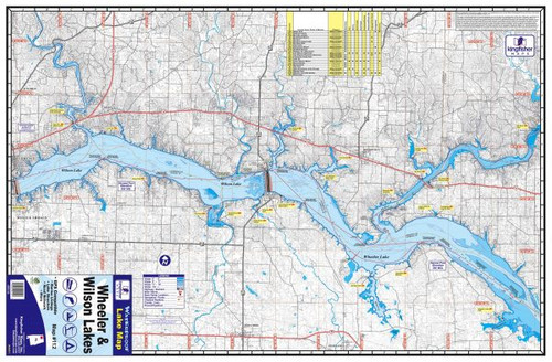
The Kingfisher Waterproof Map – Wheeler & Wilson Lakes #112 provides detailed coverage of two popular Tennessee River fisheries in northern Alabama. Covering both Wheeler Lake and Wilson Lake, this full-color topographical map is designed to help anglers and boaters identify important underwater structure, navigation features, and access points throughout both reservoirs.
The map includes detailed depth information and contour intervals, along with the river channel, buoys, boat ramps, marinas, campgrounds, and local points of interest. These details make it useful for locating ledges, channel swings, points, drops, creek mouths, and other potential fishing areas before or during a trip.
Made from waterproof and tear-resistant material, Map #112 is built for use around boats and wet fishing conditions. The map measures 23" x 35" when opened, features a two-sided design, and folds down to approximately 5.75" x 8.75" for convenient storage in a tackle bag, boat compartment, or vehicle.
Features:
- Covers Wheeler Lake & Wilson Lake, Alabama
- Kingfisher Map #112
- Full-color topographical fishing and boating map
- Waterproof and tear-resistant construction
- Two-sided design
- 23" x 35" unfolded size
- Folds to approximately 5.75" x 8.75"
- Detailed depth and contour information
- Shows river channel and navigation features
- Includes buoys
- Shows boat ramps, marinas, and campgrounds
- Includes local points of interest
- GPS compatible
- Covers Wheeler Lake near Huntsville and Decatur through Wilson Lake near Florence
- Excellent for fishing, boating, navigation, and trip planning