
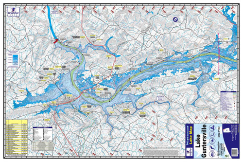
The Kingfisher Maps Lake Guntersville Waterproof Fishing Map #102 provides detailed coverage of Lake Guntersville in northern Alabama, stretching along the Tennessee River between the cities of Bridgeport and Guntersville. Designed for anglers and boaters, this full-color topographical map makes it easy to study the lake before a trip or reference important structure while you're on the water.
The map displays 5-foot contour intervals, along with river channels, creek beds, buoys, recommended tracks, marinas, campgrounds, boat ramps, and other useful lake information. The detailed contours are especially helpful for identifying points, drops, channel swings, ledges, and other underwater features that can help anglers plan productive fishing areas.
Made from waterproof and tear-resistant material, it's built to withstand the wet conditions commonly encountered in a boat. The two-sided map measures 24" x 36" when opened and conveniently folds down to approximately 6" x 9" for easy storage in a tackle bag, glove box, or boat compartment.
Features:
- Detailed Lake Guntersville, Alabama fishing map
- Kingfisher Map #102
- Waterproof and tear-resistant construction
- Full-color topographical mapping
- Two-sided design
- 24" x 36" unfolded size
- Folds to approximately 6" x 9"
- 5-foot contour intervals
- Shows river channels and creek beds
- Includes buoys and recommended tracks
- Shows marinas, campgrounds, and boat ramps
- Scale: 1:50,000
- GPS compatible
- Covers Lake Guntersville from the Bridgeport area to Guntersville
- Excellent reference for fishing, boating, and trip planning